Chiff & Fipple Orders Mandatory Evacuation

-
rebl_rn

- Posts: 810
- Joined: Tue Jun 26, 2001 6:00 pm
- antispam: No
- Location: Southeastern Wisconsin
- Contact:
I was at a bioterrorism training a year or so ago and one of the instructors was a paramedic in New Orleans. He talked about a hurricane a few years ago (I don't remember which one) that was predicted to hit N.O. Fortunately, it didn't, but the preparations in N.O. included getting tens of thousands of body bags in stock and plans to use the Superdome as a morgue, because it would have been the only place big enough to hold all the bodies.
Hopefully, with the mandatory evacuations (and it sounding like people taking it seriously) it won't be that bad, but it is scary, scary stuff indeed.
Hopefully, with the mandatory evacuations (and it sounding like people taking it seriously) it won't be that bad, but it is scary, scary stuff indeed.
Wash your hands. Cough and sneeze in your sleeve. Stay home if you are sick. Stay informed. http://www.cdc.gov/swineflu for more info.

I'm very glad that my sister and her husband no longer live in New Orleans! This looks very bad, indeed. I just read that they're using the Superdome as a storm shelter for those who can't evacuate (elderly, disabled, stranded tourists, etc.). I hope everyone comes throught it okay, but this storm is just huge; it's as intense as Camille in 1969, and considerably larger. Good luck to all in its path!
Giles: "We few, we happy few."
Spike: "We band of buggered."
Spike: "We band of buggered."


-
chattiekathy

- Posts: 793
- Joined: Fri Jul 05, 2002 6:00 pm
- antispam: No
- Please enter the next number in sequence: 8
- Tell us something.: Well dang, I just want to change my password. looking for that correct page! Thank you! Ohh good grief, I get it, you have to be careful who you let in because of spammers, but sigh.... I'm in a hurry, can we move this along please. :)
- Location: South Central PA
-
Cynth

- Posts: 6703
- Joined: Tue Nov 30, 2004 4:58 pm
- Please enter the next number in sequence: 1
- Location: Iowa, USA
HURRICANE KATRINA DISCUSSION NUMBER 24
NWS TPC/NATIONAL HURRICANE CENTER MIAMI FL
5 PM EDT SUN AUG 28 2005
KATRINA IS MAINTAINING A CLASSIC PRESENTATION ON SATELLITE
IMAGES...AND CATEGORY 5 INTENSITY. THE CENTRAL PRESSURE MEASURED
BY A NOAA HURRICANE HUNTER PLANE AT 1755Z AND 1923Z WAS 902
MB...WHICH IS THE FOURTH LOWEST ON RECORD IN THE ATLANTIC BASIN
BEHIND HURRICANE GILBERT OF 1988...THE LABOR DAY HURRICANE OF
1935...AND HURRICANE ALLEN OF 1980. HAVING SAID THAT...DATA FROM
THE STEPPED-FREQUENCY MICROWAVE RADIOMETER INSTRUMENT ON BOARD THE
AIRCRAFT SUGGEST THAT THE SURFACE TO 700 MB FLIGHT LEVEL WIND RATIO
IS NOT QUITE AS LARGE AS WE TYPICALLY USE...AND THE INITIAL
INTENSITY IS ADJUSTED SLIGHTLY TO 145 KT. HURRICANES DO NOT
MAINTAIN SUCH GREAT INTENSITY FOR VERY LONG. HOWEVER THERE ARE NO
OBVIOUS LARGE-SCALE MECHANISMS...SUCH AS INCREASED VERTICAL
SHEAR...TO WEAKEN KATRINA. THE HURRICANE IS LIKELY TO MAKE
LANDFALL WITH CATEGORY 4 OR 5 INTENSITY.
THERE IS NOT MUCH CHANGE TO THE TRACK FORECAST PHILOSOPHY. INITIAL
MOTION IS ABOUT 315/11. KATRINA IS EXPECTED TO GRADUALLY TURN
NORTHWARD INTO A BREAK IN THE SUBTROPICAL RIDGE ASSOCIATED WITH A
LARGE MID-LATITUDE CYCLONE NEAR THE GREAT LAKES. THE 12Z GFDL
HURRICANE MODEL'S TRACK HAS SHIFTED A LITTLE WESTWARD...AS HAS THE
LATEST NOGAPS RUN. THE OFFICIAL FORECAST IS SLIGHTLY TO THE WEST
AND SLIGHTLY FASTER THAN THE PREVIOUS NHC TRACK. THIS IS VERY
CLOSE TO BOTH THE DYNAMICAL MODEL CONSENSUS... AND TO THE LATEST
FSU SUPERENSEMBLE TRACK. AMONG OUR MOST RELIABLE MODELS...ONLY THE
U.K. MET. OFFICE IS SIGNIFICANTLY TO THE EAST OF THE OFFICIAL
FORECAST TRACK. IT SHOULD BE NOTED THAT THE SMALL CHANGE IN THE
OFFICIAL FORECAST TRACK IS ESSENTIALLY AT THE NOISE LEVEL. ONE
SHOULD NOT FOCUS ON THE EXACT TRACK...PARTICULARLY IN THE CASE OF A
HURRICANE AS LARGE AS THIS ONE. DESTRUCTIVE EFFECTS WILL LIKELY BE
FELT WELL AWAY FROM THE CENTER AND IT IS NOT POSSIBLE TO SPECIFY
WHICH COUNTIES OR PARISHES WILL EXPERIENCE THE WORST CONDITIONS.
ON THE BASIS OF AIRCRAFT FLIGHT LEVEL AND SFMR SURFACE WIND
DATA...THE WIND RADII HAVE BEEN EXPANDED EVEN MORE OVER THE
NORTHERN SEMICIRCLE. HURRICANE FORCE WINDS ARE FORECAST TO SPREAD
AT LEAST 150 N MI INLAND ALONG THE PATH OF KATRINA.
http://www.nhc.noaa.gov/text/refresh/MI ... 047.shtml?I hope the Federal Government is getting ready to help people down there. I suppose surely they must be.
-
rebl_rn
- Posts: 810
- Joined: Tue Jun 26, 2001 6:00 pm
- antispam: No
- Location: Southeastern Wisconsin
- Contact:
President Bush has already signed disaster declarations for Mississippi and Louisiana, which is the first step to getting the FEMA people out there. That also allows the local/state gov'ts to do what they must to help and know that they will be helped financially by the feds.Cynth wrote:I hope the Federal Government is getting ready to help people down there. I suppose surely they must be.
Wash your hands. Cough and sneeze in your sleeve. Stay home if you are sick. Stay informed. http://www.cdc.gov/swineflu for more info.
-
Tony
- Posts: 5146
- Joined: Wed Aug 08, 2001 6:00 pm
- antispam: No
- Please enter the next number in sequence: 8
- Tell us something.: I used to play pipes about 20 years ago and suddenly abducted by aliens.
Not sure why... but it's 2022 and I'm mysteriously baack... - Location: Surlyville
This Hurricane is massive
http://www.ssd.noaa.gov/PS/TROP/DATA/RT ... -loop.html
http://www.ssd.noaa.gov/PS/TROP/DATA/RT ... -loop.html
-
Dale

- The Landlord
- Posts: 10293
- Joined: Wed May 16, 2001 6:00 pm
- Please enter the next number in sequence: 1
- Location: Chiff & Fipple's LearJet: DaleForce One
- Contact:
Thanks, Kathy. Angela & company arrived safely in Oxford, Mississippi for shelter so they are out of harm's way.chattiekathy wrote:My prayers are with all those in Katrina's path. Especially Angela and her friends. My nephew and his wife are in Pensecola. They also are preparing for it to hit.
Kathy
Power may go down here at C&F HQ in Birmingham, AL, maybe as early as Tuesday. We'll be inconvenienced but safe. I'm so very worried about people in New Orleans and all those coastal and even inland areas. I just saw the head guy from the NOAA Hurricane Center on CNN and he said there is just no way to avoid this one being an enormous catastrophe.


Oh, how sad! This is what they have feared for years. On the Tulane campus, the dorms and buildings . . . everything . . . are built up 6 feet or so in the event of flooding, but this will be horrendous. The water isn't going to drain out afterward.
Tulane was in the middle of new-student orientation . . . they told them all to evacuate. I wonder how long it will be before the school is able to open again, if ever.
Maybe other colleges can each take a few students for the year.
This is the projection of the wind speeds inland (the "MEOW" or maximum envelope of winds), assuming a Cat. 5 moving at 12 knots (it's at 11, but the closest choice was 12). Storms blow out quickly over land, but the bigger the storm, the farther inland it takes to blow out.
Cotelette d'Agneau
-
Dale
- The Landlord
- Posts: 10293
- Joined: Wed May 16, 2001 6:00 pm
- Please enter the next number in sequence: 1
- Location: Chiff & Fipple's LearJet: DaleForce One
- Contact:
I think the problem is that it's a worst-case scenario. The most vulnerable major city and one of the largest hurricanes ever recorded headed right for it. In New Orleans, tens of thousands unable to evacuate. Then, due to the sheer size of the storm, a huge area to produce casualties.OnTheMoor wrote:I thought I heard the Red Cross representative on CNN say something about them preparing for this as the worst natural disaster they have ever dealt with in the US. Is that right or did I hear wrong?
http://start.earthlink.net/article/nat? ... 1965666757
http://start.earthlink.net/article/nat? ... 1206311107
This was what Hurricane Andrew did to Homestead, Florida in 1992. There were people in those homes during the storm.
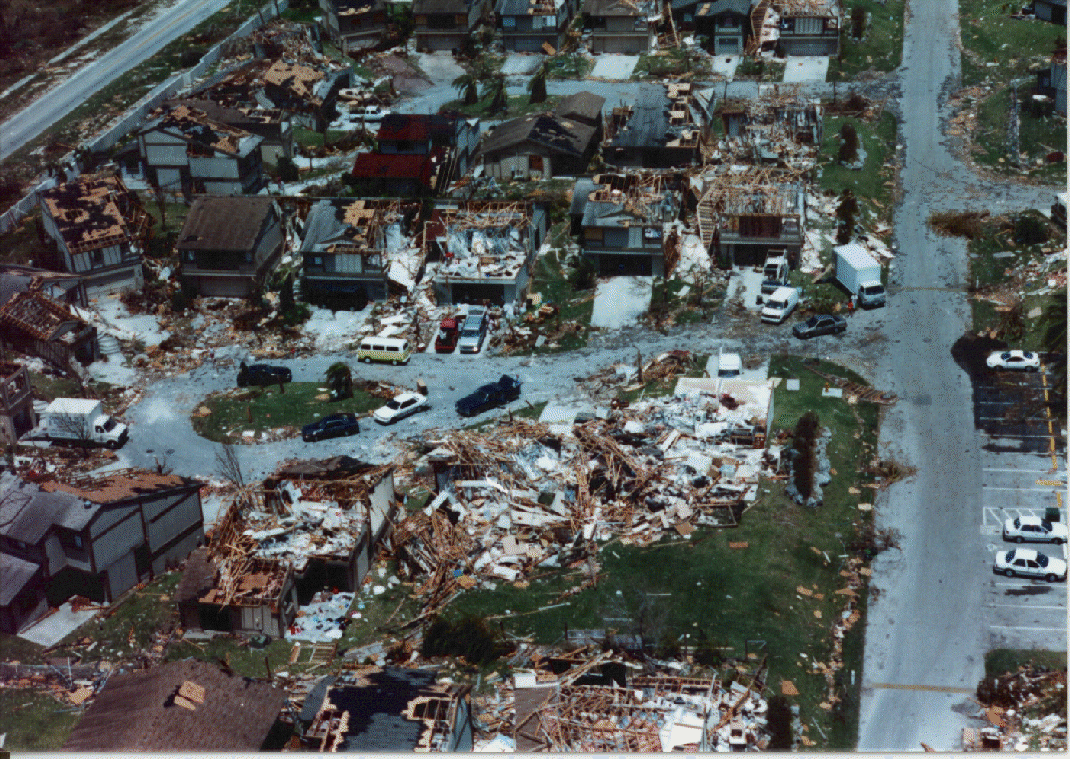
In 1965, when a hurricane partially flooded New Orleans, the aftermath was as bad as the storm. When people got back to their homes, poisonous snakes and dead, dying, and injured wild animals were everywhere in them. The flood waters were half sewage. Some of my professors in graduate school remembered it all, as the public health problem had been horrendous.
http://start.earthlink.net/article/nat? ... 1206311107
This was what Hurricane Andrew did to Homestead, Florida in 1992. There were people in those homes during the storm.
In 1965, when a hurricane partially flooded New Orleans, the aftermath was as bad as the storm. When people got back to their homes, poisonous snakes and dead, dying, and injured wild animals were everywhere in them. The flood waters were half sewage. Some of my professors in graduate school remembered it all, as the public health problem had been horrendous.
Cotelette d'Agneau