more maps
-
mutepointe

- Posts: 8151
- Joined: Wed Jan 04, 2006 10:16 pm
- Please enter the next number in sequence: 1
- Location: kanawha county, west virginia
- Contact:
-
mutepointe
- Posts: 8151
- Joined: Wed Jan 04, 2006 10:16 pm
- Please enter the next number in sequence: 1
- Location: kanawha county, west virginia
- Contact:
Re: more maps

Rose tint my world. Keep me safe from my trouble and pain.
白飞梦
白飞梦
-
mutepointe
- Posts: 8151
- Joined: Wed Jan 04, 2006 10:16 pm
- Please enter the next number in sequence: 1
- Location: kanawha county, west virginia
- Contact:
Re: more maps
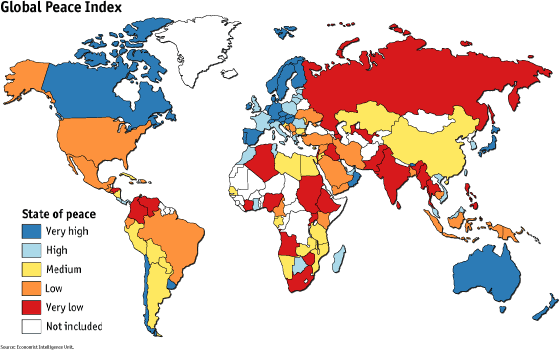
Here is a link to a lot of interesting maps.
http://twistedsifter.com/2013/08/maps-t ... the-world/
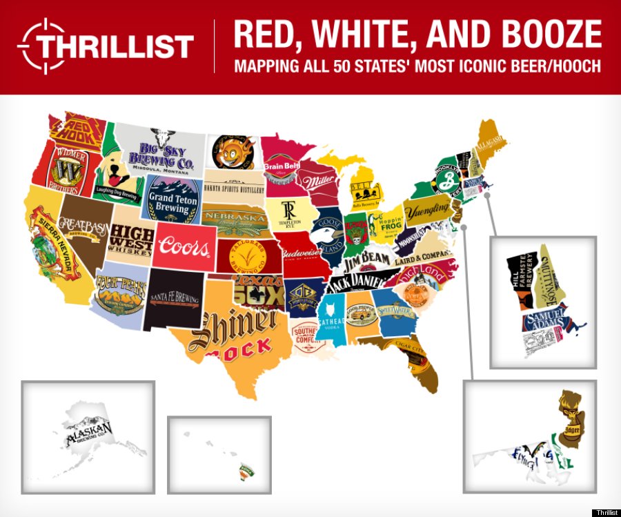
This is one of my favorites.

http://twistedsifter.com/2013/08/maps-t ... the-world/
This is one of my favorites.
Rose tint my world. Keep me safe from my trouble and pain.
白飞梦
白飞梦
Re: more maps
That (the highest-paid one) is pretty telling . . .
-
ytliek

- Posts: 2739
- Joined: Mon Feb 06, 2012 3:51 pm
- antispam: No
- Please enter the next number in sequence: 10
- Location: Seashore
Re: more maps
You've been outted.
http://twistedsifter.com/2013/08/maps-t ... the-world/
Better yet, see the timed photos that follow.
http://twistedsifter.com/2013/08/maps-t ... the-world/
Better yet, see the timed photos that follow.
-
mutepointe
- Posts: 8151
- Joined: Wed Jan 04, 2006 10:16 pm
- Please enter the next number in sequence: 1
- Location: kanawha county, west virginia
- Contact:
Re: more maps
I have been out and proud. I posted the link to twistedsifter myself. I love maps. Is that so wrong?ytliek wrote:You've been outted.
http://twistedsifter.com/2013/08/maps-t ... the-world/
Better yet, see the timed photos that follow.
Rose tint my world. Keep me safe from my trouble and pain.
白飞梦
白飞梦
-
mutepointe
- Posts: 8151
- Joined: Wed Jan 04, 2006 10:16 pm
- Please enter the next number in sequence: 1
- Location: kanawha county, west virginia
- Contact:

-
MTGuru

- Posts: 18663
- Joined: Sat Sep 30, 2006 12:45 pm
- antispam: No
- Please enter the next number in sequence: 8
- Location: San Diego, CA
Re: more maps
The "American" category on the US Census always cracks me up.
Vivat diabolus in musica! MTGuru's (old) GG Clips / Blackbird Clips
Joel Barish: Is there any risk of brain damage?
Dr. Mierzwiak: Well, technically speaking, the procedure is brain damage.
Joel Barish: Is there any risk of brain damage?
Dr. Mierzwiak: Well, technically speaking, the procedure is brain damage.

Re: more maps
That is a little weird. I live in one of the "American"-majority counties. I often give my breeding as "American mutt" because my family's been in North Carolina so long and cared so little about lineage (aside from being decidedly Southern) that we can't place any particular Old World ancestry. You get that answer a lot around here. I wonder if it has to do with the White poor in the Southeast being unwilling or unable to trace their ancestry.MTGuru wrote:The "American" category on the US Census always cracks me up.
Re: more maps
It appears that those of German ancestry win the cumulative-acres award.
-
mutepointe
- Posts: 8151
- Joined: Wed Jan 04, 2006 10:16 pm
- Please enter the next number in sequence: 1
- Location: kanawha county, west virginia
- Contact:
Re: more maps
I think it's weird too. Where I live now, people don't know what they are. We have very few ethnic festivals where I live.fearfaoin wrote:That is a little weird. I live in one of the "American"-majority counties. I often give my breeding as "American mutt" because my family's been in North Carolina so long and cared so little about lineage (aside from being decidedly Southern) that we can't place any particular Old World ancestry. You get that answer a lot around here. I wonder if it has to do with the White poor in the Southeast being unwilling or unable to trace their ancestry.MTGuru wrote:The "American" category on the US Census always cracks me up.
I grew up near Pittsburgh where, "So where's your family from?" is a common ice breaker. Then the person gives their complete lineage,(bonus points for Ellis Island!) A friend from out west moved here and didn't know his lineage. He found it necessary to make one up.
My Dad's side of the family is German. They spoke German until World War I. Never after that.
Rose tint my world. Keep me safe from my trouble and pain.
白飞梦
白飞梦
-
Sirchronique
- Posts: 1014
- Joined: Sun Sep 09, 2012 9:56 pm
- antispam: No
- Please enter the next number in sequence: 8
- Tell us something.: I like whistles, flutes, lyres, cittern/mandolin/bouzouki family instruments, as well as heavy and nasty slap bass. Languages, linguistics, history (especially Migration Period and Bronze Age Europe), cuisine from various parts of Latin America, chili growing, bushcraft, and the works of JRR Tolkien also tickle my fancy.
- Location: Southern Indiana
Re: more maps
Here's an interesting video somebody posted on facebook the other day on the topic of maps. It's worth checking out.
http://www.upworthy.com/we-have-been-mi ... ?g=2&c=bl3
It's a clip from some TV show, but it's actually not fictional.
Probably nothing new to many of you, but in the school I attended we were taught with the inaccurate Mercator map, mostly. I assume the Mercator map has been common in most other schools in the United States, too, unfortunately.

Re: more maps
Any time you project a sphere onto a flat plane there are going to be compromises. Selecting a map projection involves making judgements about which compromises are more or less important to you. The Mercator projection world map has been much maligned of late because it does distort the relative size of land masses. While I'll grant that it's probably good for kids to realize that Greenland is not, in fact, larger than South America, there is another issue here. There seems to be an undercurrent to the Mercator bashing that implies its presence is part of some plot to intentionally belittle the people and cultures of the Southern Hemisphere. This ignores the question of what advantages it might possess to have made it so popular in the first place.Sirchronique wrote:Probably nothing new to many of you, but in the school I attended we were taught with the inaccurate Mercator map, mostly. I assume the Mercator map has been common in most other schools in the United States, too, unfortunately.
Imagine drawing a line from Chicago to Seattle on a map and then getting into an airplane at O'Hare. You take off and set your compass heading to 295.1. A Mercator map is the only projection where you would actually pass over every point on the line. If your primary objective is navigation then the Mercator map is very useful. If it's important to you to show graphically that London is as far north as Montreal then the Mercator map works well for that also. If your goal is to emphasize that Africa is larger than North America then you'll want to look at using another projection. Any two-dimensional map projection is going to contain distortions. To call one accurate and another inaccurate is ill-considered.
I'm asking you because you're an educated sort of swine. John LeCarre
-
Sirchronique
- Posts: 1014
- Joined: Sun Sep 09, 2012 9:56 pm
- antispam: No
- Please enter the next number in sequence: 8
- Tell us something.: I like whistles, flutes, lyres, cittern/mandolin/bouzouki family instruments, as well as heavy and nasty slap bass. Languages, linguistics, history (especially Migration Period and Bronze Age Europe), cuisine from various parts of Latin America, chili growing, bushcraft, and the works of JRR Tolkien also tickle my fancy.
- Location: Southern Indiana
Re: more maps
MikeS wrote:Any time you project a sphere onto a flat plane there are going to be compromises. Selecting a map projection involves making judgements about which compromises are more or less important to you. The Mercator projection world map has been much maligned of late because it does distort the relative size of land masses. While I'll grant that it's probably good for kids to realize that Greenland is not, in fact, larger than South America, there is another issue here. There seems to be an undercurrent to the Mercator bashing that implies its presence is part of some plot to intentionally belittle the people and cultures of the Southern Hemisphere. This ignores the question of what advantages it might possess to have made it so popular in the first place.Sirchronique wrote:Probably nothing new to many of you, but in the school I attended we were taught with the inaccurate Mercator map, mostly. I assume the Mercator map has been common in most other schools in the United States, too, unfortunately.
Imagine drawing a line from Chicago to Seattle on a map and then getting into an airplane at O'Hare. You take off and set your compass heading to 295.1. A Mercator map is the only projection where you would actually pass over every point on the line. If your primary objective is navigation then the Mercator map is very useful. If it's important to you to show graphically that London is as far north as Montreal then the Mercator map works well for that also. If your goal is to emphasize that Africa is larger than North America then you'll want to look at using another projection. Any two-dimensional map projection is going to contain distortions. To call one accurate and another inaccurate is ill-considered.
Indeed, I am in agreement. I was referring more to the inaccuracies of the representations of the size of land-masses. I don't really have an issue with the mercator map, or it's being taught in schools. My point in posting it is that unfortunately for people like me, this is the *only* map one is exposed to throughout their entire schooling up through until their adulthood, meaning that this is what has formed their entire concept of what size the different landmasses actually are. I believe the video itself even points out the reason for the mercator map, which I don't think anyone has any reason to disagree with in itself.
Admittedly though, until recently I had no idea about the size distortions present in the mercator map. So, by all means, it has it's place, but I think people should be aware that it's not representing the actual scale of things on the map, hence why I shared it here. The difference is huge enough that I think it should at least be mentioned to everyone that it doesn't show proper scale, and that both maps should be widely-known, and the flaws and benefits of what they both represent should be pointed out.
Otherwise, you will have people like me, and many others, who nearly get into their mid-twenties thinking greenland really is that huge. I'm not sure how anyone can agree that it's alright to use one map to create anyone's entire concept of what the earth actually looks like. That's what has happened, unfortunately.
That's my point- Not a problem with the map, but with the fact that it's been the sole map used to teach things that the map does not accurately illustrate. I'd say there would be an equal issue if the peterson map were used to teach about precise navigational subjects, likewise.
If each map requires a sort of comprimise, then multiple maps should be used that do not comprimise on the precise point that the map is being used to teach at that time.
I don't think the mercator map is part of any negative plot, but I do indeed think it can have such effects on a person's concept of the world, even if not brought about intentionally.
-
mutepointe
- Posts: 8151
- Joined: Wed Jan 04, 2006 10:16 pm
- Please enter the next number in sequence: 1
- Location: kanawha county, west virginia
- Contact:
Re: more maps
Not to worry folks. In the very near future, I don't doubt that we'll have virtual 3-D globes that float in front of us, like in the Sci-Fi movies.
Rose tint my world. Keep me safe from my trouble and pain.
白飞梦
白飞梦